It was still dark when the alarm sounded in our first floor
room of the Zafiro Hotel
 located in the small village of Pelluco, overlooking
Puerto Montt Bay. Joaco and I were
sharing a room, and two of Joaco’s brothers, Claudio and Gonzalo, were in
another room on the second floor. We heard them heading down the stairs so, as
agreed the night before, we went directly to the dining room, quickly downed a cup of classic Chilean
Nescafe and a nondescript ham and cheese sandwich. We loaded our bags into our Mitsubishi
4-wheel drive vehicle, and took off into the thick mist of what apparently was
going to be a cloudy, rainy day, the type of day you would expect in early
spring in this part of southern Chile.
Forty five mostly paved kilometers later, we arrived at the ReloncavÍ Estuary and pulled onto an almost empty sloping cement
ramp in Puerto La Arena, where we hoped to board the barcaza, a 10-12 vehicle ferry, which would take us across to
Puelche.
located in the small village of Pelluco, overlooking
Puerto Montt Bay. Joaco and I were
sharing a room, and two of Joaco’s brothers, Claudio and Gonzalo, were in
another room on the second floor. We heard them heading down the stairs so, as
agreed the night before, we went directly to the dining room, quickly downed a cup of classic Chilean
Nescafe and a nondescript ham and cheese sandwich. We loaded our bags into our Mitsubishi
4-wheel drive vehicle, and took off into the thick mist of what apparently was
going to be a cloudy, rainy day, the type of day you would expect in early
spring in this part of southern Chile.
Forty five mostly paved kilometers later, we arrived at the ReloncavÍ Estuary and pulled onto an almost empty sloping cement
ramp in Puerto La Arena, where we hoped to board the barcaza, a 10-12 vehicle ferry, which would take us across to
Puelche.
Pelluco, where we began this journey an hour earlier, is at
the southern end of Route 5, the Pan-American Highway, and on the northernmost
end of what is now Route 7, the Carretera
Austral. We were committed to
traveling the length of this newest of Chilean roads all the way to the
southern end, Villa O’Higgins, and we were filled with anticipation of the
adventure that lay ahead. We had twelve
days to drive down the road, and return, so we were on a pretty tight schedule
and had left Pelluco early so we would not miss the first barcaza crossing of the day.
And it was a good thing we did, because shortly after we pulled our
vehicle into line on the ramp in La Arena, several large trucks that transport fish fingerlings for the
aquaculture cages operating all along the coast began to line up also, and it began to
look like everyone was not going to be able to get on the first ferry. We needed to be on the first ferry, because
we had a reservation on another obligatory barcaza
crossing further south that was scheduled to depart at 11 AM later this same
morning.
 |
| Puerto La Arena |
It was still dark, lightly raining, as we waited, and we had
some time to spare so we explored the few buildings that make up La Arena and
watched as others showed up to cross with us.
It was hard to believe that I was finally going to fulfill my dream of
travelling the Carretera Austral, so as I stood under a makeshift shack
designed to sell snacks and drinks, but closed this time of year, I reflected
on what this trip meant, and why I was so sure it was going to be such a
wonderful experience.
In the late 1960s, I began exploring Chile’s 5,000 kilometer
length made up of desert, fertile central valley, majestic Andean mountains, pristine
native forests, rugged Pacific coastline, beautiful lakes, wild rivers, fjords,
and permanent ice fields, from Arica on the border with Peru in the north to
Punta Arenas on the Straights of Magellan in the south. Early on in my discovery of the breathtaking
natural wonders of what was to become my “second home”, I recall that at that
time, now more than 40 years ago, most Chileans when they took time off during
the summer vacation months of January and February would head to the coastal
cities (Viña del Mar, Valparaíso, La Serena) or towns (Algarrobo, Zapallar, El
Quisco, Papudo, Cachagua, Santo Domingo) where they essentially regrouped into
their Santiago-based social-familial groups to enjoy the cold surf, welcoming
beaches, all night discos and abundant fresh seafood. They tended to hug the coast in their spare
time, very few of them venturing into the regions of lakes and rivers further
south.
We were young Peace Corps Volunteers at the time, so although
we also enjoyed an occasional visit to the shore, but the more modest beach towns of
Constitución, Dichato, and Cartagena, we were more likely to vacation in the
southern lakes region, fishing and hiking, and collecting artisan products in
the markets of Chillán,
Temuco, and Puerto Montt. These were
also the areas that North American and European tourists were most interested
in visiting; Lago Todos los Santos, Villarrica and Pucón, Puyehue National
Park, and especially, in the southern extreme of the country, the spectacular
Torres Del Paine with its high snow covered peaks, blue tinged glaciers, and
lakes filled with icebergs and surrounded by virgin mixed hardwood and
araucaria forests.
These unparalleled natural areas have been developed over
the past forty years in systems of national parks, reserves, thermal spas, ski
slopes, and private resorts and camping areas.
Now, the Pan-American Highway that runs over 3,350 kilometers down the
center of the country from Arica on the
Peruvian border in the north to Puerto Montt and on to Quellón at the southern
extreme of the Grand Island of Chiloé is a paved two and sometimes three lane
high-speed toll road. LAN Chile airline flies
several times daily to Puerto Montt, Punta Arenas, Coyhaique and Concepción, and
modern luxurious buses travel between every city and town along the way. So these days, for most of the year, foreign tourists and
Chileans alike easily reach what is called the 10th region, Región de Los Lagos, with its lakes, rivers, forests, and high
volcanic mountains to hike, camp, fish, and generally relax in one of the most
beautiful natural areas of the world.
South of Puerto Montt, the Región de Los Lagos
extends to the tip of the Island of Chiloé, but also along a 250 kilometer
strip of the mainland on the east that borders Argentina. The Gulf of Ancud and
the Gulf of Corcovado separate the Grand Island of Chiloé from this strip of the
mainland. The Island of Chiloé has been settled and developing for decades, in
the recent past the victim of scandalous overexploitation of the native
hardwood forests to provide wood chips to Asian wood products industries and
now where the aquaculture industry is producing record levels of Atlantic
salmon, oysters, and mussels for voracious export markets.
In contrast, the mainland section of the Región de los Lagos and the neighboring
11th region, Región de los Ríos
further south, were relatively unsettled, an area of over 1,000 kilometers in
length of wild, untouched land containing the most spectacular rivers, mountain
peaks, active volcanoes, permanent glaciers, and virgin native forests in the world,
bordered on the east by Argentina and on the west by the Pacific Ocean. For much of its length the Andes Mountains
run right down the middle. These
mountainous lands, cut transversally by wild rivers rushing to the sea,
remained for the most part without roads. One city, Coyhaique, the capital of
the 11th region, located over 600 kilometers south of Puerto Montt
and about 1600 kilometers north of Punta Arenas, was connected by some form of
roadway since the early 1940s/50s with Puerto Aysén where water travel was
available north and south to other parts of Chile, and in the 1960s via Puerto Ibáñez
with Argentina directly to the east. Puerto Cisnes, a small port north of Coyhaique
was connected to Argentina via a road in 1935, and Chaitén to the border area of Lago Yelcho
and Palena. But for the most part this
entire region of Chile, until recently, was cut off from the rest of Chile, and
also from itself.
However, in 1976, Chile’s military government took the game-changing
decision to begin what would be one of the most ambitious road building
projects in the world, and in 23 years, using the Cuerpo Militar del Trabajo, CMT, Chile’s military corps of
engineers, constructed over 1,000 kilometers of road stretching from Puerto
Montt to Villa O’Higgins, a very small frontier town on the tip of a branch of
Lago O’Higgins, a huge lake fed by melted waters from the Campo de Hielo Sur glacier before they flow northward and westward
to the Pacific Ocean. Geopolitics played
a large role in the decision to construct this road; the Argentines were
developing much more aggressively their side of the Andes in this extensive ,
and strategic, area in southern South America called Patagonia (road building on the eastern slopes of the Andes is much
easier than on the Chilean west side), and it certainly did not escape the
Chilean military leaders that as their neighbor was establishing a network of
hard surface roads all along their side of the Andes, the Chileans were simply
feeding into that system with feeder roads running east-west, void of
north-south connections within Chile.
Relations between the two countries have not always been friendly, so
this situation was untenable.
By the year 2000, this newly constructed combination of road
systems and ferry crossings, at that time called Carretera Austral Augusto Pinochet, rustic as it was in its first
form, provided a way to travel by land from Puerto Montt south through mainland
Chiloé Province, further south through Aisén Province, to Lago O’Higgins and
the frontier town of Villa O’Higgins.
But to travel this road system was a chore, since just a few kilometers
were paved near Chaitén and around the Coyhaique/Puerto Aisén area, and the
rest were gravel and dirt tracks that were often impassable in the winter months
of June through September, or terribly dusty and dangerous the rest of the
year. And, the area offered very few
lodging and eating establishments. So
initially only a few hardy explorers made the trip, but the area had been
opened up, especially for four wheel drive vehicles, these rugged vacationers
found unparalleled spectacular natural areas for hiking, camping, ice climbing,
fishing, canoeing and white water rafting, and of course they passed the word
on to others.

 So here we were, at 7 AM on a rainy Monday morning, our
first day out, getting onto this barcaza
that is going to take us from Caleta La Arena to Caleta Puelche, a lovely 30
minute ride that in spite of the low clouds and cool drizzle still allows a
glimpse of the magnificent peaks of Parque Nacional Alerce Andino we are leaving
behind and the imposing volcanic peaks of Parque Nacional Hornopirén we are
approaching. We do not have much time to
spare as we disembarqued in Caleta Puelche and headed towards the village of
Hornopirén, about 60 kilometers away, where our 11 AM ferry should be waiting
for us. The road skirts the shoreline
from Puelche through Mañihueico to Contao, passing numerous salmon farm rafts
floating just off shore. Many of the passengers
on the first ferry are only going this far to spend several days working these aquaculture
operations before returning to their homes in Puerto Montt for a few days of
rest.
So here we were, at 7 AM on a rainy Monday morning, our
first day out, getting onto this barcaza
that is going to take us from Caleta La Arena to Caleta Puelche, a lovely 30
minute ride that in spite of the low clouds and cool drizzle still allows a
glimpse of the magnificent peaks of Parque Nacional Alerce Andino we are leaving
behind and the imposing volcanic peaks of Parque Nacional Hornopirén we are
approaching. We do not have much time to
spare as we disembarqued in Caleta Puelche and headed towards the village of
Hornopirén, about 60 kilometers away, where our 11 AM ferry should be waiting
for us. The road skirts the shoreline
from Puelche through Mañihueico to Contao, passing numerous salmon farm rafts
floating just off shore. Many of the passengers
on the first ferry are only going this far to spend several days working these aquaculture
operations before returning to their homes in Puerto Montt for a few days of
rest.

Contao has a notorious history. It is the area where, in the
late 1960s, a large US logging operation (Simpson) obtained a concession from
the government of Chile to harvest alerce
logs in the hilly area above the village of Contao. I recall flying by small, single-engine plane
into this operation in 1968 to collect samples of the wood they were extracting,
for a project I was involved with at the Instituto Forestal where I was working
as a Peace Corps Volunteer. The alerce harvesting operation turned out
to be a bust, due mainly to the high cost of harvesting logs in such an adverse
terrain, but also because the magnificent alerce
trees were so old that many of them were much hollower than the projections had
estimated, and therefore had less marketable wood. The alerce
is now declared a National Monument in Chile, and cannot be harvested, but due
to the similarity of alerce wood to that
of the US redwood, way too much of Chile’s millennial virgin alerce forest was destroyed; one ignominious
center of this crime was Contao, which we were just now passing by on our way
south.
 |
| Departing Horopiren |
Our research prior to this trip led us to believe that from
Hornopirén we would take a six hour ferry trip around the western side of
Peninsula Huequi to Caleta Gonzalo, from where we would again pick up the
Carretera Austral and proceed to Chaitén.
However, when we made reservations for the 11 AM barcaza from Hornopirén, we were informed that instead of one ferry
direct to Caleta Gonzalo there were now two, the first a 5-6 hour trip from
Hornopirén along the eastern side of the peninsula to Vodudahue, at the northern
entrance to Parque PumalÍn, followed by a
quick drive of about a half hour through the park to the small port of Leptepu,
and the second a short ferry trip to Caleta Gonzalo.
 |
| Hornopiren Plaza |
We had some time in Hornopirén, a welcoming type of town, so
we visited the town’s tourism office and landmark church, before buying some
essentials (a few bottles of wine) for the upcoming five hour trip through the
Comao Fjord. Hornopirén sits in a
picturesque site where the RÍo Negro flows into
the fjord. It is itself a good base for
several excursions into the surrounding area. Hiking, camping, boating and
fishing are available in the nearby Parque Nacional Hornopirén, or short trips
can be taken down the coast to the small towns of Cholgo and Pichanco where
numerous salmon farming rafts dot the coastal waterway. Another option from Hornopirén is to explore
by boat the island of Llancahue and the Islas de los Ciervos, which sit right
across the fjord from Cholgo and Pichanco.
 |
| Comao Fjord |
 |
| Dave, Joaquin, Claudio, Gonzalo |
However, we had reservations on the 11 AM ferry so we could
reach Chaitén by nightfall; off we went down the Comao Fjord. This is a
fantastic way to see this part of continental Chiloé. The ferry cruises between the Llancahue
Island and the Islas de los Ciervos, and eventually between the mainland coast
and the Peninsula Huequi, with its snowcapped volcanoes and hot springs (Termas
de Porcelana). This five hour ride, even
with low hanging clouds and intermittent rain, is awesome. We could tell that while it was raining where
we were, it was snowing on the treed tops of the mountains we were passing
by. Because the ferries operated in this
region by Navimag have very comfortable enclosed seating for passengers, including
a snack bar where hot coffee, soft drinks, and snacks can be

 purchased, we sat
inside and enjoyed the scenery as we shared a lunch of meat empanadas and the two bottles of
Castillo de Molina 2011 Cabernet sauvignon we had purchased that morning. After a conversation about Chilean politics
with a retired engineer from Punta Arenas, one with a young employee of the
Chilean Health Service who was headed to Chaitén to do an inspection of the
waste management program of the hospital, and a somewhat heated exchange on the
dangers and virtues of genetically modified organisms (GMOs) with a
not-so-young widow farmer who was returning to her sheep farm in La Junta
(south of Chaitén) after visiting her daughter in Puerto Montt where she is
studying nursing, I was rewarded with a well-earned wine induced nap.
purchased, we sat
inside and enjoyed the scenery as we shared a lunch of meat empanadas and the two bottles of
Castillo de Molina 2011 Cabernet sauvignon we had purchased that morning. After a conversation about Chilean politics
with a retired engineer from Punta Arenas, one with a young employee of the
Chilean Health Service who was headed to Chaitén to do an inspection of the
waste management program of the hospital, and a somewhat heated exchange on the
dangers and virtues of genetically modified organisms (GMOs) with a
not-so-young widow farmer who was returning to her sheep farm in La Junta
(south of Chaitén) after visiting her daughter in Puerto Montt where she is
studying nursing, I was rewarded with a well-earned wine induced nap.
 |
| Arriving Caleta Gonzalo |
The sun began to peek through the clouds and as we
approached Puerto Gonzalo it began to look like the forecasts for better weather
for the next few days might be accurate.
The 60 kilometers of gravel road from Gonzalo to Chaitén crosses the
Parque PumalÍn, the controversial private
natural reserve US billionaire conservationist Robert Thompkins purchased and then donated to a
newly created foundation to be operated as a private national
park. Environmentalists love that Tompkins
did this, and as we drove through this part of the park it became obvious
why. The land has been locked up and for
the most part will remain undeveloped except for facilities that support
visitors who want to experience and explore this large area of natural forest,
 |
| Giant Alerce |

including some of the best remnants of alerce
forests and beautiful tree-lined lakes that you can see only by hiking in from
the main road and camping. We stopped
and followed a trail into a swampy area of giant alerce trees, some of the way walking along on felled alerce logs two meters in diameter. To stand next to a majestic monument like the
Chilean alerce is to feel the very
best of nature, but also to want to cry for the very worst of what man has done to this
king of a tree.
Before reaching Chaitén, we passed by Santa Bárbara, a
fishing village with a beautiful tree-lined beach, where the highway actually
becomes a landing strip, widened on both sides to accommodate the aircraft,
mostly private, flying in with visitors to PumalÍn.

Chaitén is a devastated town. In 2008 the Chaitén Volcano that sits right
next to town erupted violently and for days covered the surrounding area,
including neighboring Argentina, with tons of ash. The town of Chaitén, with its 5,000
inhabitants, was covered with as much as two meters of ash.
 |
| Mud and rock flow from the volcano |
 |
| Chaitén |
National and Regional authorities decided the
best action to take was to encourage the town to move permanently to another
site; they moved the public services to nearby Palena and made Palena the
capital of the province. But more
importantly, and probably because they saw no future in this town, they did not
make an effort to clear the meters-deep ash from the streets and roads, nor
from watercourses such as the RÍo Blanco which runs
right through the center of the town.
Several days after the eruption, as the ash was building up in and
around Chaitén, the waters resulting from the ice-melt on the volcano came
rushing through town, overflowed the banks of the river due to the accumulated
ash, and flooded the homes, businesses, schools and churches of this ill-fated town. The town on the
south side of the river was completely leveled, while the north side fared a
bit better, but overall, Chaitén was a ghost town for a couple of years at
least, with very little hope of being rebuilt and no official interest in doing
so.
 |
| Main street in northern Chaitén |
However, five years later when we drove into this town, the
current authorities had reversed the plan to create “New Chaitén” near Santa Bárbara,
and instead were beginning to support the efforts of prior residents to
resettle the original town, at least on the north side of the river that has been
declared “habitable”. Just this year the
public services of civil registry, internal revenue service, and housing
ministry have reopened offices in this part of Chaitén, and at least 1,800
residents are moving back from the surrounding towns where they had taken
refuge in 2008. Many of these residents had challenged the official orders not
to return to their homes, and some have lived in the town without public
services of gas, water, and electricity for as long as two years.
 Fortunately for us, two of those residents, Carlos and
Lidia, have established the Hostal Don Carlos, where we spent a very
comfortable first night on our trip down the Carretera Austral. There are
other places to stay in Chaitén, and more are popping up as returnees and new
entrepreneurs settle into Chaitén, which is now attracting many more visitors
than before due to it’s unfortunate notoriety, and the increasingly more
passable Carretera Austral. The hospital, totally destroyed, is now being
rebuilt and is operating partially; a new ambulance is servicing the
community. The Army’s Mounted
Exploration Unit returned to inhabit the old Army Regiment facilities near Chaitén
after our visit, and a new airstrip will be opened in early 2014.
Fortunately for us, two of those residents, Carlos and
Lidia, have established the Hostal Don Carlos, where we spent a very
comfortable first night on our trip down the Carretera Austral. There are
other places to stay in Chaitén, and more are popping up as returnees and new
entrepreneurs settle into Chaitén, which is now attracting many more visitors
than before due to it’s unfortunate notoriety, and the increasingly more
passable Carretera Austral. The hospital, totally destroyed, is now being
rebuilt and is operating partially; a new ambulance is servicing the
community. The Army’s Mounted
Exploration Unit returned to inhabit the old Army Regiment facilities near Chaitén
after our visit, and a new airstrip will be opened in early 2014.
 |
| Joaco, Dave and Claudio at El Volcán |
Lidia prepared delicious pisco sours for us shortly
after our arrival and then recommended we eat dinner at “El Volcán”, just a couple of
blocks away and around the corner, so we grabbed two bottles of Rabanal 2011 Cabernet
sauvignon that we had purchased in Hornopirén, and enjoyed our first dinner on
the road; juicy roast beef, rice, and lettuce salad. That night back in the very cozy family room
of the Hostal, we initiated a series of nightly discussions of the day’s events,
with the able assistance of our travelling companion, Jack Daniels. We slept well, in part because of the "spirits" of the place, but also because we had arisen around 5 AM, travelled by land over
200 kilometers over half of which was rough gravel road, taken three ferry
crossings totaling about 7 hours, and hiked into an alerce forest in Parque PumalÍn. An excellent day one, we all agreed.
 |
| Volcán Chaitén from the village |
Early the next morning, after a great breakfast of toasted
homemade bread with thick butter, bittersweet blackberry jam, scrambled eggs,
ham, and coffee with rich whole milk, we departed Chaitén. The skies were clearing, and in the bright,
cool morning air the still-smoking volcano, an imposing threat lurking above
the town, was a spectacular sight to behold.
As we started out, our plan for the day was to get as far as
Puerto Cisnes, a little less than 300 kilometers south of Chaitén. The road was paved for about an hour south of
Chaitén, until we reached the southern end of Parque PumalÍn, where we were treated to a most magnificent view of
Volcán Michinmahuida to the north.
Further along, again on firm gravel roadway, we drove along the RÍo Yelcho, crossed one of
 the attractive suspension bridges
as we left Puerto Cardenas at the northern end of beautiful Lago Yelcho,
crossed another where the waters from the Ventisquero Yelcho Chico run into the
lake, climbed through the Moraga Pass (highest point on the road), eventually
reaching Villa Santa Lucia. At this
point you can turn eastward towards Argentina, to the towns of Futaleufú
the attractive suspension bridges
as we left Puerto Cardenas at the northern end of beautiful Lago Yelcho,
crossed another where the waters from the Ventisquero Yelcho Chico run into the
lake, climbed through the Moraga Pass (highest point on the road), eventually
reaching Villa Santa Lucia. At this
point you can turn eastward towards Argentina, to the towns of Futaleufú
 |
| Lago Yelcho |
or Palena, both of
which are about a two hour drive from the Carretera
Austral, located just before border crossings into Argentina. This whole area is well known for excellent
salmon and trout fishing, spectacular mountain hiking and camping, and white
water rafting.
 Passing up the opportunity to visit Futaleufú or Palena , we
continued south from Villa Santa Lucia where the road begins to border Parque
Nacional Corcovado, and Rio Frio, until it finally crosses into the 11th Region,
Aisén, where it borders the Rio Palena that flows westward from Argentina
eventually into the Pacific Ocean’s Golfo Corcovado. About 140 kilometers south of Chaitén we
reached the town of La Junta, a relatively new town previously called
"Medio Palena” of somewhere around 1,200 inhabitants.
Passing up the opportunity to visit Futaleufú or Palena , we
continued south from Villa Santa Lucia where the road begins to border Parque
Nacional Corcovado, and Rio Frio, until it finally crosses into the 11th Region,
Aisén, where it borders the Rio Palena that flows westward from Argentina
eventually into the Pacific Ocean’s Golfo Corcovado. About 140 kilometers south of Chaitén we
reached the town of La Junta, a relatively new town previously called
"Medio Palena” of somewhere around 1,200 inhabitants.
 |
| La Junta |
 |
| market in La Junta |
La Junta is named for its location at the
confluence of two beautiful rivers, the Rosselot that carries crystalline
waters from Lago Rosselot to the sea, and the Palena. Before the Carretera Austral was built, towns like La Junta associated more
with Argentina and Argentine culture than with the rest of Chile, in spite of
the fact that the area was used to raise livestock that were taken down the
line to Puyuhuapi and then by boat to Puerto Montt. From La Junta, if fishing is your objective,
short trips east to Lago Rosselot and Lago Verde are highly recommended. La Junta offers gasoline and a couple of
stores selling all sorts of food and supplies, so it is becoming an important
stopping point for travelers at this point of the Carretera Austral. We picked
up a couple of bottles of Cousiño Macul Don LuÍs
(appropriately rustic for the location) and ingredients for ham and cheese sandwiches,
and enjoyed a light lunch on the shore of Lago Rosselot.
 |
| Lago Rosselot |
We were making good time, in spite of the fact that through
this part of Aisén the road was becoming rougher and we were not able to drive
as fast as we would have liked. As we
left La Junta, we left the beautiful RÍo
Palena behind, and drove through an area of pastures along the RÍo Risopatrón that flows north from Lago Risopatrón, near
Puyuhuapi, our next destination, to join up with the RÍo Palena near La Junta.
As we proceeded, we were driving through two other beautiful protected natural
areas, the Reserva Nacional Lago Rosselot and the Parque Nacional Queulat,
along the narrow Lago Risopatrón.
 |
| Entrance to Puyuhuapi |
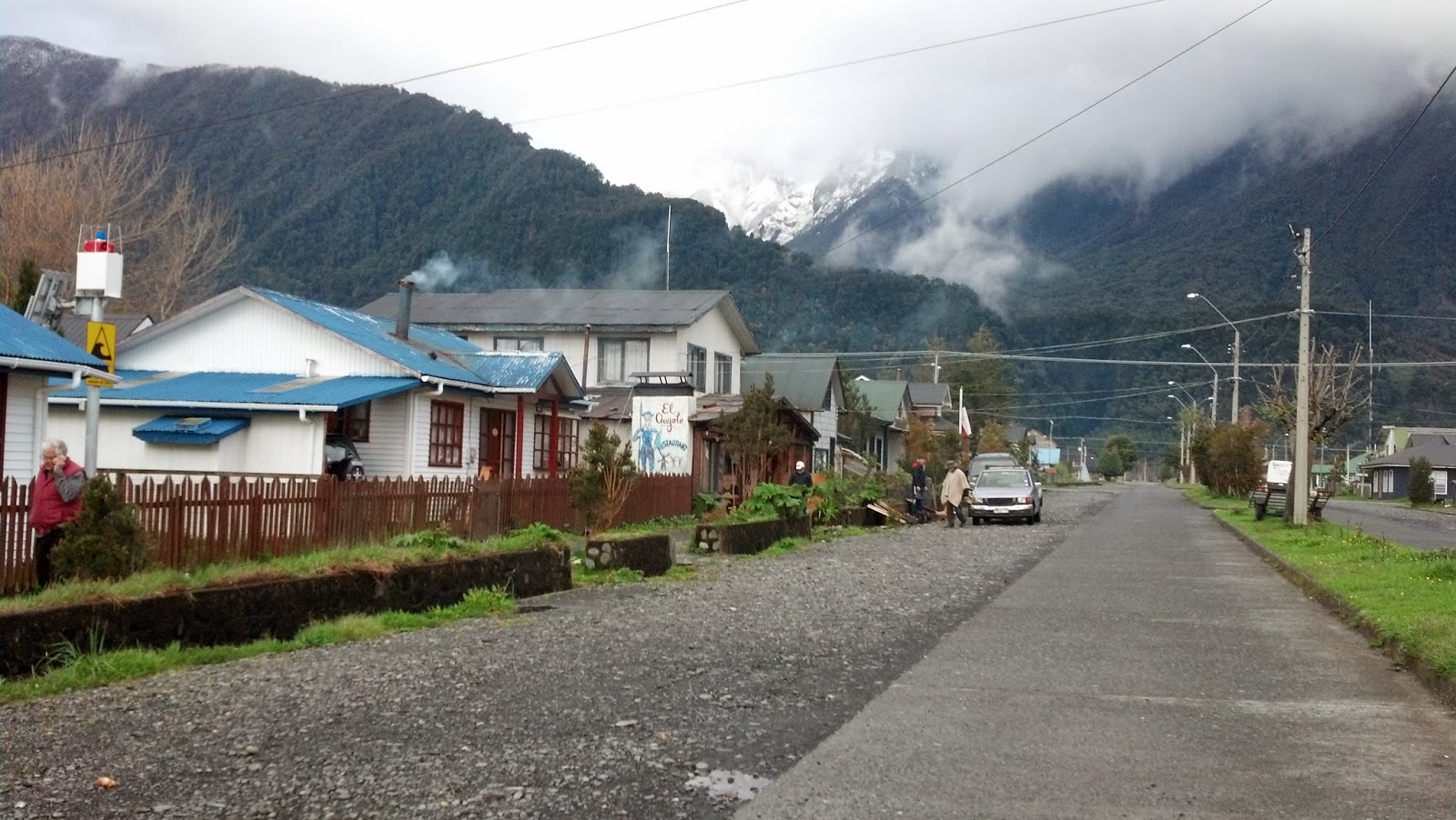
 As we drove into the small town of Puyuhuapi, it became very
clear to us that we were now entering an area of Chile very different and
incredibly spectacular. This town,
located in the middle of continental Aisén, less than 100 kilometers from the
Argentine border, sits comfortably at the tip of the Ventisquero fjord and
offers a very mixed bag of lodging, from rustic camping to very comfortable
resorts, several boasting therapeutic hot springs. Of special interest also is a well-established,
high quality artisan rug factory, worthy of a visit if they happen to be open
when you are visiting.
As we drove into the small town of Puyuhuapi, it became very
clear to us that we were now entering an area of Chile very different and
incredibly spectacular. This town,
located in the middle of continental Aisén, less than 100 kilometers from the
Argentine border, sits comfortably at the tip of the Ventisquero fjord and
offers a very mixed bag of lodging, from rustic camping to very comfortable
resorts, several boasting therapeutic hot springs. Of special interest also is a well-established,
high quality artisan rug factory, worthy of a visit if they happen to be open
when you are visiting.
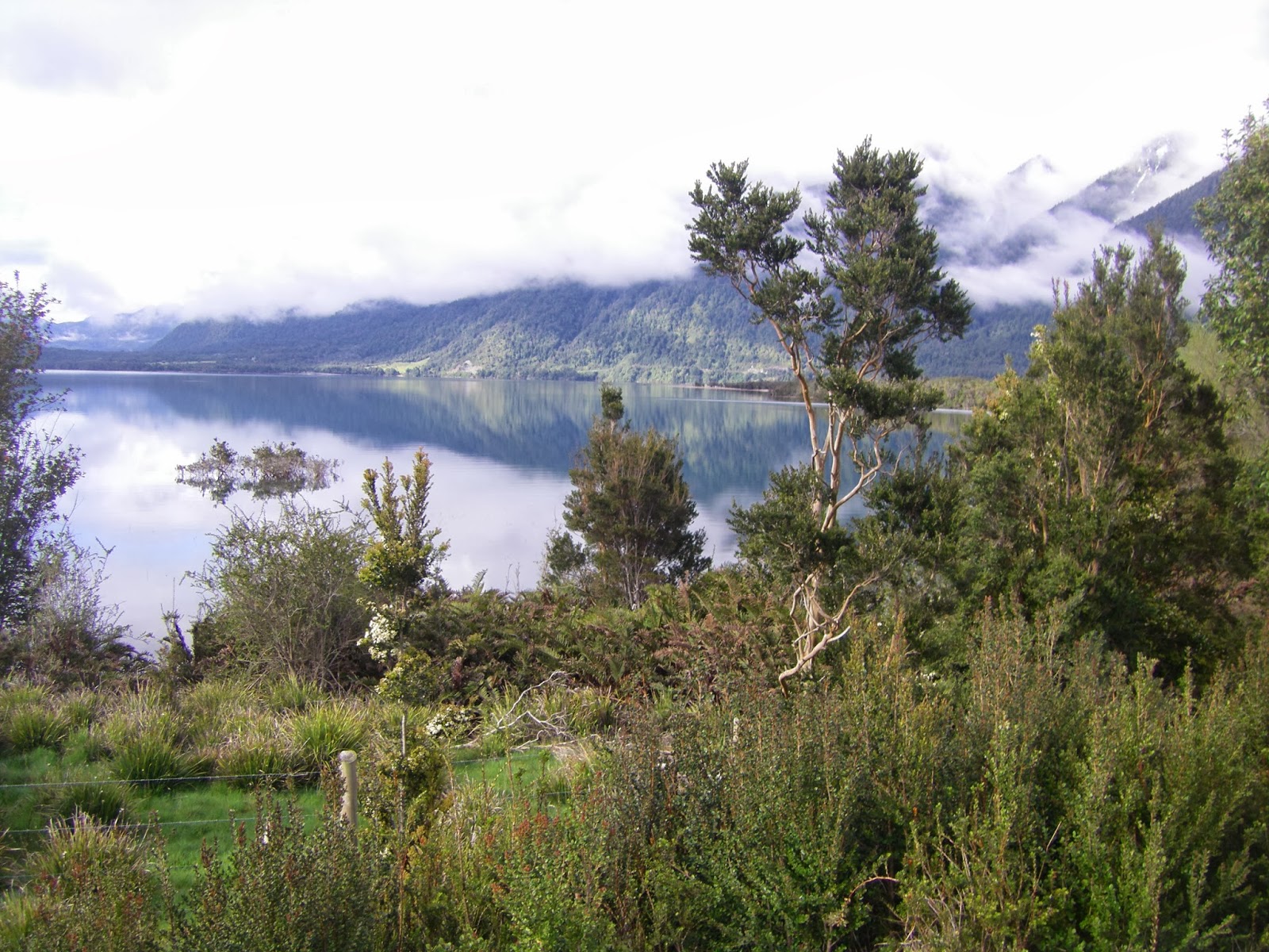
We continued south, along the fjord, and stopped at a simple
but pleasant hot springs spa that offered outside hot baths situated right on
the water’s edge, with incredible views across the water of Isla Magdaleña and Volcán Mentolat in the distance
in the center of Parque Nacional Isla Magdaleña. The temptation
to stay put for a while and take advantage of this beautiful spa was almost irresistible. A discussion ensued between the four of us,
as to what was best; stay here for a good soak and drive in the dark to arrive
late in Puerto Cisnes, or proceed. The
opinion was split down the middle; two of us wanted to stay, two wanted to
proceed, but we passed up what would have been a very refreshing hiatus in our
journey, because our main objective of this trip was to drive the entire length
of the Carretera Austral, and if we
were going to go all the way to Villa O’Higgins at the end, we could not stop
for very long in any one spot, regardless of how tempting. So we pushed on.
 |
| Ventisquero Colgante |
Just a bit further south of Puyuhuapi there is a large aquaculture
center producing Atlantic salmon you find in the US at Costco, and a pier from
which, if you are fortunate enough to have reservations a boat will take you to
the Puyuhuapi Lodge and Spa, located on the Magdaleña Island in the middle of the lush native forest that
contains not just trees but also those big, Jurassic ferns. Clearly, a stay at this lodge would be a
wonderful experience, so as we sped by on our journey to the end of the road we
all felt slightly guilty that the four of us were having such a wonderful time
seeing for the first time such a beautiful part of Chile, and we vowed we would
return to spend more time here, but next time with our respective wives. This idea was further cemented in our minds
a little later when we entered the Queulat National Park and took a short hike
to a lookout with an amazing view of the Ventisquero
Colgante, a huge glacier that seems to hang precariously over the lush
valley below. We spent quite a bit of
time just taking in this sight, such an imposing mass of ice, thrusting itself
out of the Andes Mountains, feeding impressive waterfalls with fresh water from
the melting ice.
As we drove through Parque Nacional Queulat, we were greeted
with remnants of an earlier snowfall, making the road a little dangerous but
the surrounding forest a wonderland. On
the downside of the pass we went through Piedra Del Gato, where a road
to Puerto Cisnes branches west from the Carretera. This road, paved earlier but being repaved
and therefore mostly firm gravel for the moment, follows
the winding RÍo Cisnes through the Andes Mountains that at this point
are very close to the Ocean, to Puerto Cisnes.
 |
| O'Higgins in Puerto Cisnes Plaza |
 |
| Eugenia Pirzio Biroli |
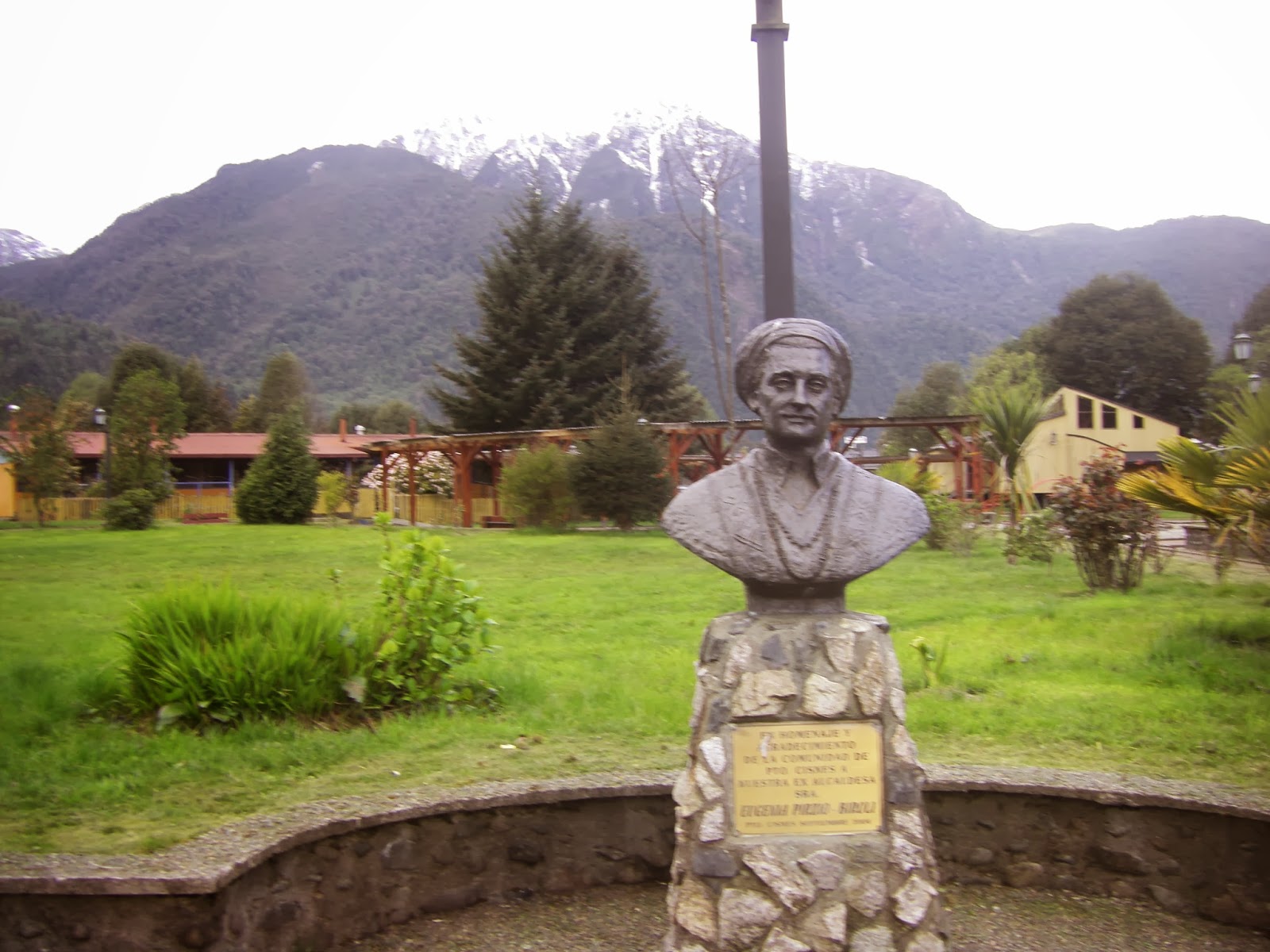
I have always wanted to visit Puerto Cisnes, because way back during the
years I worked in Chile with the Peace Corps, there was a woman mayor (something of an anomaly at the time) of this
extremely isolated town in Aisén, Eugenia Pirzio Biroli, who made herself famous by forcefully taking
her town’s and her people’s needs directly to the national government in
Santiago, at times sitting in the anterooms of powerful officials including
Presidents until her persistence paid off with an audience so she could appeal
face-to-face and usually successfully for more services and infrastructure for her town and her people.
 |
| Library in Cisnes |
 |
| School in Cisnes |
Puerto Cisnes is the main population center of a vast area
of islands with small fishing villages and totally untouched natural areas some
of which are included in huge national parks.
It is a welcoming town, but they may still feel somewhat neglected; as
we enjoyed a walk through the lovely central park, a car with a couple of
matronly citizens stopped to encourage us to visit their port-side restaurant
for some of “the best seafood empanadas
you have ever eaten”. We passed up the
invitation, not knowing what all might be involved in those empanadas, but we did enjoy how
civilized Puerto Cisnes seems to be, with a prominent municipality building, colorful
and obviously active cultural center and
library, surely due to the influence of the prior mayor. But, in spite of finding the town quite
interesting and pleasant, we did not see any obvious places to spend the night,
so again we decided to continue our travels, this time all the way to
Coyhaique, the capital of the 11th Region.
 |
| Hotel Ñirre |
 |
| Coyhaique |
Tired of travelling, hungry but mostly thirsty, we checked
into a classic hotel, Los Ñirres, just off the plaza, ordered double pisco
sours all around, had a nice dinner of Aysén beef matched with a very good 2009
Cabernet sauvignon, Ventisquero Grey. We
were joined for dinner by a young lawyer, relative of ours, who has lived in
Coyhaique for several years. During our
very lively conversation he mentioned more than once that the beef cattle
sector in the Aysén region of the Chilean Patagonia had been “ruined” by
Tompkins, the American behind the Parque PumalÍn we
had driven through the past two days. I
had a hard time understanding this, and still am not sure if this argument
holds together, but it seems that prior to the establishment of control over
the huge national parks and establishment of private preserves like PumalÍn, livestock owners were free to let their cattle roam
almost anywhere, even far afield from the owners lands and into public
lands. As more attention was given to
protecting public and private reserves (Thompkins was and still is an
active force in this movement) livestock were kept out of these lands, and
the entire regime of raising cattle in this region was changed. It represents another case of changing
public preference for natural area protection over extensive farming, with the
collateral damage to traditional practices, causing sometimes divisive public
policy struggles. This explains in part
the proliferation of signs we saw all along the Carretera Austral stating “PATAGONIA SIN TOMPKIN$” in pretty bold terms.
Coyhaique is not only the capital of the 11th
Region of Chile; it is the kick off point for most people who visit the Carretera Austral. For years tourists have been flying to
Balmaceda airport, about 50 kilometers southeast of Coyhaique, joining tours or
renting cars to visit Puerto Aysén and Puerto Chacabuco, and from there to go
by boat to Laguna San Rafael where, by water, one can get close up to a
monumental glacier, even have a glass of scotch cooled with millennial ice from
the glacier. Or, from Coyhaique you can
continue south on the Carretera Austral,
which is what we had planned to do, so we left the Puerto Aysén, Puerto
Chacabuco, Laguna San Rafael excursion to a later date, “with our wives”, we
promised again.
 |
| Cuesta del Diablo, Cerro Castillo, Rio Ibanez |
 |
| Cerro Castillo |
 Our destination on day three was Cochrane, a city about 360
kilometers south of Coyhaique. We had
been told the road was really bad, and that we would not make very good time,
so we left early. Our information was
correct; this part of the road is receiving some major work, so there are places where we
faced delays while work crews blasted away rock and waited while heavy
machinery smoothed out detours around places where new bridges would be built.
Also, the road was just rougher than what we had travelled up to now. Driving slower did have its own reward,
though, since the scenery was absolutely magnificent as we passed through the
Our destination on day three was Cochrane, a city about 360
kilometers south of Coyhaique. We had
been told the road was really bad, and that we would not make very good time,
so we left early. Our information was
correct; this part of the road is receiving some major work, so there are places where we
faced delays while work crews blasted away rock and waited while heavy
machinery smoothed out detours around places where new bridges would be built.
Also, the road was just rougher than what we had travelled up to now. Driving slower did have its own reward,
though, since the scenery was absolutely magnificent as we passed through the
 |
| Kids in Villa Castillo |
 |
| Villa Castillo |
 |
| El mate in Villa Castillo plaza |
Reserva Nacional Cerro Castillo and into the glacier area of
southern Patagonian Chile. We stopped for a few minutes in Villa Castillo, a small place with the most friendly children in the world, and a very attractive wood carved stature of a mountain dweller offering mate to whomever passes by. From here on to Cochrane the road travels along the east side of a tall range of the Andes
and west of a smaller range, the snowcapped peaks visible the whole way even as it drops to
hug the shore of one branch of Lago
General Carrera.

We arrived at RÍo Tranquillo, where we stopped
to take a two-hour boat trip to visit a series of marble-like rock formations in and on the shore of the lake, including the amazing Catedral de Mármol,
 |
| Puerto Rio Tranquillo |
 |
| Catedral de Mármol |

 carved out by the action of the waves over the years. The Catedral, a marvel of nature yet unspoiled by the crush of tourism, is an obligatory stop for anyone traveling on this part of the Carretera Austral.


 |
| Cochrane |
 |
| Huemul statue in Cochrane |
Upon reaching Cochrane, the last “city” on the Carretera Austral, we checked out the
Military Hotel we had been told might have rooms where we could spend the night. My travelling companions were anxious to stay
here, so they practiced standing tall and straight, brisk salutes, and recalled
details of all the military “experience” they would profess so that we might
“talk and look military” and have a better chance to get a room. We agreed I would stay quiet so as not to
reveal my true character of “gringo” (read CIA in the southern hemisphere), sometime-pacifist, and
more to the point non-apologist for the earlier military dictatorship. So I stayed in the
background as the others made their case at the hotel. I was secretly hoping we would not be
accommodated, although it was an attractive, modern facility, so I was discretely relieved as we were turned away with the excuse
that there were no vacant rooms. Gonzalo, the youngest brother, like I, sports
a full beard; he concluded that we were turned away due to the military’s deep
distrust of beards. The others felt that
their stories of past military experience (mostly made up or greatly
exaggerated), were not convincing; they surely were not! I, on the other hand, think they simply did
not have any free rooms. Anyway, we were
offered alternative simple but comfortable lodging at the residence of the woman who
manages the kitchen in the military hotel, MarÍa (of course).
After checking in, we were treated to an especially wonderful meal at
ADA’s Café and Restaurant where we feasted on oven-roasted Patagonian lamb, stewed
rabbit, and grilled Aysén beef.
 |
| Our "hotel" in Cochrane |
 |
| Dinner at Ada'S |
A couple
of bottles of 2010 Santa Carolina Barrica Selection, Cabernet sauvignon Gran
Reserva, a late night discussion we again invited Jack Daniels to join, and we
slept soundly in spite of the purple walls, red bedspreads and pink lace curtains
in this funky “hotel-in-progress”.
We were awakened early on Day four, 4:30 to be precise, by a
trio of frustrated roosters who, sitting right below our windows but out of
reach of the rocks we threw at them, incessantly begged us to rise and shine, so
we got another early start. MarÍa provided us with a wonderful
breakfast at the military hotel, and we departed on the southernmost leg of our trip which would be capped off by a triumphant entry later in the afternoon,
into Villa O’Higgins, our ultimate destination at the end of the Carretera Austral.
The drive from Cochrane to Villa O’Higgins is a relatively
easy one, mostly on a new hard packed gravel road, the most recent section of the Carretera Austral to be opened.

 It passes small deep-green lagoons, a series
of waterfalls, newly constructed bridges over the Barrancoso River, and
spectacular views of RÍo Baker.
We passed the turnoff to Caleta Tortel, and
continued on to Puerto Yungay where we took the barcaza Padre Antonio Ronchi across the
Mitchell Fjord to RÍo Bravo Landing. We would visit Caleta Tortel on our way back
north the next day after visiting Villa O’Higgins.
It passes small deep-green lagoons, a series
of waterfalls, newly constructed bridges over the Barrancoso River, and
spectacular views of RÍo Baker.
We passed the turnoff to Caleta Tortel, and
continued on to Puerto Yungay where we took the barcaza Padre Antonio Ronchi across the
Mitchell Fjord to RÍo Bravo Landing. We would visit Caleta Tortel on our way back
north the next day after visiting Villa O’Higgins.
 |
| Barcaza Padre Ronchi |
 |
| Lago Cisnes |
 Forests of the native hardwoods Lenga and Ñirre
line long sections of this road, along which, now that the area is opened up to
vehicular traffic, homesteaders are staking out their properties and building
cabins and more substantial homes and lodges, including some fantastic places
for visitors who want to fish the cold waters of the Bravo and Mayer rivers.
Forests of the native hardwoods Lenga and Ñirre
line long sections of this road, along which, now that the area is opened up to
vehicular traffic, homesteaders are staking out their properties and building
cabins and more substantial homes and lodges, including some fantastic places
for visitors who want to fish the cold waters of the Bravo and Mayer rivers.

 At one point in our travel down this last section of the Carretera, we were entertained by
several majestic condors, two of which were sunning themselves on the branches
of a dead tree right beside the road. A
bit further down the road you must pass through a forested area where the huemul is apt to be seen. After seeing the condors, we hoped to also
view a huemul, the pair being the
iconic figures on the Chilean coat-of-arms, but they were not around the day we
went by, one of a very few disappointments on this trip.
At one point in our travel down this last section of the Carretera, we were entertained by
several majestic condors, two of which were sunning themselves on the branches
of a dead tree right beside the road. A
bit further down the road you must pass through a forested area where the huemul is apt to be seen. After seeing the condors, we hoped to also
view a huemul, the pair being the
iconic figures on the Chilean coat-of-arms, but they were not around the day we
went by, one of a very few disappointments on this trip.

After following the beautiful RÍo
Bravo for about 50 kilometers, we crossed the Coronel Van Schouwen suspension
bridge over the Mayer River and drove into Villa O’Higgins, a new town of about
500 inhabitants, and our destination. Villa O’Higgins sits at the tip of Lago
O’Higgins, about a kilometer from the Argentine border. The lake extends to the east into Argentina,
where it is named Lago San MartÍn; it is fed by
melting glaciers of Campo de Hielo Sur, a huge permanent ice field surrounded
by Bernardo O’Higgins national park to the west and Los Glaciares national park
to the east. Villa O’Higgins is an
exciting place, not only because it is at the end of the carretera, but also because from here you can explore into the
fjords, lakes, and glaciers of this so far wild and untouched area where only a fortunate few have visited.
 |
| Entrance to Villa O'Higgins |
 There is clearly some official interest in settling more
people and commercial activities in Villa O’Higgins, several new housing
developments have been established with subsidies from the national government,
there are at least two churches, several small hotels, lodges, and cafes and
restaurants; a new high-end hotel named
Robinson Crusoe - Deep Patagonia provides very comfortable, and pricey,
lodging.
There is clearly some official interest in settling more
people and commercial activities in Villa O’Higgins, several new housing
developments have been established with subsidies from the national government,
there are at least two churches, several small hotels, lodges, and cafes and
restaurants; a new high-end hotel named
Robinson Crusoe - Deep Patagonia provides very comfortable, and pricey,
lodging.
 |
| Robinson Crusoe-Deep Pategonia |


 We decided to stay here, to get
a good night’s sleep to prepare for the long journey back to Santiago starting
the next day. Before dinner we walked
along the river bed outside of town to the Paso RÍo Mosco at the Chile/Argentine border, and then drove down
the road a bit beyond town to a boat launching site on the lake from which we could get a closer, clearer
look at the imposing Mosco glacier.
Given the geopolitical sensitivity of this border town, and the absolute
raw beauty of the surroundings, Villa O’Higgins is a destination worth the
effort it takes to arrive, and worthy of a stay of several days to enjoy one of
the most beautiful, naturally striking areas in Chile.
We decided to stay here, to get
a good night’s sleep to prepare for the long journey back to Santiago starting
the next day. Before dinner we walked
along the river bed outside of town to the Paso RÍo Mosco at the Chile/Argentine border, and then drove down
the road a bit beyond town to a boat launching site on the lake from which we could get a closer, clearer
look at the imposing Mosco glacier.
Given the geopolitical sensitivity of this border town, and the absolute
raw beauty of the surroundings, Villa O’Higgins is a destination worth the
effort it takes to arrive, and worthy of a stay of several days to enjoy one of
the most beautiful, naturally striking areas in Chile.
 |
| Villa O'Higgins |
 |
| New housing |
 |
| O'Higgins in Central Plaza |
 |
| church |
 |
| more new housing |
 |
| Radio station |
 |
| another church |
Dinner at the Lodge was preceded by a round of super double pisco sours, cooled with glacier ice (we were told) enjoyed by the fireplace in
the second floor sitting room of the main Lodge. A fine but modestly sized plate of tender
strips of filet of beef, oven roasted potatoes, and green salad was facilitated
by a good amount of Gran Tarapacá Cabernet sauvignon, capped off
with the last whimper from our pal Jack Daniels, who abandoned us at this point. We sat around the fireplace the rest of the
evening, entertained by the lodge manager Daniel who described how his share of
the very successful Robinson Crusoe seafood processing company was turned into
this “Deep Patagonia” hotel and extreme tourism enterprise, which over the next
couple of years will establish a world class set of activities for visiting by
boat, foot, and horse the lakes, rivers, fjords, glaciers, and forests of this
still wild paradise.
 We had reached our destination…and we were content, but very
tired, so we slept well.
We had reached our destination…and we were content, but very
tired, so we slept well.

Day five started early for us, since we had to reach the RÍo Bravo landing, three hours
away, to take the morning barcaza
back across to Puerto Yungay, and on to Caleta Tortel where we planned to have
lunch.
 Caleta Tortel is a small unique village
perched on the shore of the RÍo
Baker delta, between the Campo de Hielo Norte and Campo de Hielo Sur. Originally, and to a lesser degree today, the
main activity in Tortel was capturing the huge Ciprés de Las Guaitecas logs harvested from the forests
up-river and floated down to the sea, to be loaded onto ships that would take
the logs south to Punta Arenas, Puerto Natales, and north to Puerto Montt.
Caleta Tortel is a small unique village
perched on the shore of the RÍo
Baker delta, between the Campo de Hielo Norte and Campo de Hielo Sur. Originally, and to a lesser degree today, the
main activity in Tortel was capturing the huge Ciprés de Las Guaitecas logs harvested from the forests
up-river and floated down to the sea, to be loaded onto ships that would take
the logs south to Punta Arenas, Puerto Natales, and north to Puerto Montt.
 |
| Wood sculptures depicting Tortel's traditional logging activity |
What is so special about Tortel is that this
town of about 500 inhabitants has no roads; transportation from the parking
area above the town, and within the town, is entirely via wooden walkways made
from the same sturdy, resistant ciprés.

Breakfast on Day six again at the Military Hotel, and we were
off on the last stretch of our trip in Chile, for today we were to drive along
the south side of Lago General Carrera, and cross over into Argentina at the
border town of Chile Chico to begin our long drive north through the Argentine
Patagonia. Lago General Carrera is a
bi-national lake, 60% in Chile and 40% in Argentina where it is called Lago
Buenos Aires.
It eventually empties into
the Pacific Ocean at Caleta Tortel via RÍo Baker. The road we
wanted to take turned off the Carretera
Austral just north of Puerto Bertrand.
 |
| Near Beltrand |
 |
| Lago General Carrera |
The trip along the lake to Chile Chico is an easy, but a bit dangerous,
drive. Loose gravel with steep drop-offs
can be treacherous, but as long as everyone drives with caution it is one of
the loveliest drives in Chile. And Chile
Chico is a nice border town, with restaurants and stores for the traveler. Ferries travel across the lake regularly to
and from Puerto Ibañez,
connecting Chile Chico and travelers with a more expeditious route to Coyhaique. We had our last meal in Chile at the Restaurant Turismo de Chile
Chico : crispy but moist broiled salmon, and lukewarm beer.
 |
| Ferry from Chile Chico to Pto. Ibañez |
For the next three days we drove north through Argentina,
stopping for the night in Perito Moreno, San Carlos de Bariloche and San MartÍn de Los Andes, before crossing
back into Chile through the Mamuil Malal pass at the foot of magnificent Volcan
LanÍn, then through Pucón,
Villarrica, and eventually back onto the Pan-American highway and home in
Santiago. An account of this part of our trip trough Argentina deserves a separate literary effort, left to another day.
We had accomplished our objective of driving from one end of
the Carretera Austral to the other; five thousand kilometers through the most
beautiful natural areas in the world.
Along the way each bend in the road revealed a place, a side road, a
trail, a river, a lake, and wonderfully happy people that beg you to stay for
days if not weeks, and they especially expect you to enjoy their wonderful land. Our trip was one
focused on the pure satisfaction of driving this road as few people have done;
certainly most have not traveled the entire length from Puerto Montt to Villa
O’Higgins. Instead of what we did, most
visitors choose just a section of the Carretera
and spend more time exploring the surroundings.
And frankly, that is the way to really appreciate this part of
Chile, so now that we have satisfied our crude macro-desire, we are already
planning longer but more precise visits to more limited areas on the Carretera.
One interesting route is Puerto Montt, Chaitén, Futaleufú, and back through Argentina to
Chile at Puyehue, then Osorno. This route is great as long as you traverse the Puerto Montt to Chaitén route by land, including the three barcaza crossings. Another
is what most people do; fly to Balmaceda to visit Coyhaique and surroundings, Puerto
Aysén, and Laguna San
Rafael. But the trip I want to make, and suggest to others,
before it becomes too popular, is an extension of this by adding on a
visit to Villa O’Higgins for a few days to enjoy that very special place
nestled in the Andes right next to Campos de Hielo Sur and Lago O’Higgins.
As I am finishing up this rambling account, the Santiago newspapers
are filled with news and opinions on the World Court’s recent determination
regarding the Peru-Chile border almost five thousand kilometers north of Villa
O’Higgins. Chileans seem distraught over
the possibility that Peru, with their legal challenge, might have accomplished wresting some of Chile’s
maritime economic exclusive control over a portion of the Pacific Ocean 80
kilometers off the coast of Arica.
Probably there are important geopolitical issues at stake, so I am not
suggesting Chileans should not be concerned; maybe they should even be
more upset at the outcome. What I am wondering, though, is
how attentive the Chilean authorities are to the vast terrestrial and maritime
riches along the entire length of the Carretera
Austral we just visited, as well as further south to and beyond Punta
Arenas. Is there serious strategic
thinking being forged to guide development of the areas along the entire
Argentine-Chilean border that runs the length of the country, but especially in
the southern Patagonia region we just visited?
Is the next “surprise” of challenged or even lost patrimony going to be in the south due to
a lack of serious national presence, protection, and development in the border area?
On one of our last nights on the Carretera Austral, we happened to be staying in the same hotel as
the mayor of Villa O’Higgins. We had
seen the new housing developments in Villa O’Higgins, and other effects of the
opening up of the Carretera, and I,
for one, thought that the mayor would be excited about the prospects
for his town and the area now that the Carretera is finally being finished. However, to my surprise he
divulged very deep-felt anxiety, and disappointment, with the Santiago-centric
Chilean national authorities, who, to paraphrase, “…have never paid nearly enough
attention to the challenges of developing and defending the incredible natural
resources held in trust in the south of Chile, not the present ones, not the prior ones, nor any before them ”.
Maybe now a new government, helped along by the impact of the
Peru-Chile border issue, will figure out how to provide the incentives necessary
for serious investments in the distant regions of Chile, especially
the “deep Patagonian south”. The Carretera Austral, a mammoth undertaking
to be sure, is just the first step in a process whereby Chileans begin to take
full advantage of their rich natural endowment.
My hope is that they follow through with careful development of the
entire area through which we travelled on the Carretera Austral, by committing to a model of development that
encourages increased economic activity while preserving the vast protected
areas of the national parks, reserves, wild rivers and lakes which can attract lucrative tourism and sustain in
the long run any human settlements.
In the meantime, good readers, my suggestion is that if you
ever wanted to travel the Carretera
Austral in Chile, you should do it NOW!
Posted in Santiago, Chile, on February 2, 2014


 Continuing on towards Cochrane, the road skirts the west
side of Lago General Carrera but also
provides to the west unparalleled views of the glaciers of Compo de Hielo Norte that sit between the road and the ocean and
feed several small lakes with icy water ultimately flowing into Lago General
Carrera and Lago Bertrand.
Continuing on towards Cochrane, the road skirts the west
side of Lago General Carrera but also
provides to the west unparalleled views of the glaciers of Compo de Hielo Norte that sit between the road and the ocean and
feed several small lakes with icy water ultimately flowing into Lago General
Carrera and Lago Bertrand. 
 Puerto Bertrand
sits on the point where RÍo
Baker begins its 200 kilometer rush to the sea, and for most of the rest of the
journey to Cochrane we followed this magnificent river, imagining all the fish
we would catch, clean and grill, the next time we came to this part of Chile
with more time to linger.
Puerto Bertrand
sits on the point where RÍo
Baker begins its 200 kilometer rush to the sea, and for most of the rest of the
journey to Cochrane we followed this magnificent river, imagining all the fish
we would catch, clean and grill, the next time we came to this part of Chile
with more time to linger. 


 On our way to Cochrane we stopped to visit the Mellizas falls, requiring negotiating with a local shepard to open the gate for us.


No comments:
Post a Comment