It was still dark when the alarm sounded in our first floor room of the Zafiro Hotel
 located in the small village of Pelluco, overlooking Puerto Montt Bay. Joaco and I were sharing a room, and two of Joaco’s brothers, Claudio and Gonzalo, were in another room on the second floor. We heard them heading down the stairs so, as agreed the night before, we went directly to the dining room, quickly downed a cup of classic Chilean Nescafe and a nondescript ham and cheese sandwich. We loaded our bags into our Mitsubishi 4-wheel drive vehicle, and took off into the thick mist of what apparently was going to be a cloudy, rainy day, the type of day you would expect in early spring in this part of southern Chile. Forty five mostly paved kilometers later, we arrived at the ReloncavÍ Estuary and pulled onto an almost empty sloping cement ramp in Puerto La Arena, where we hoped to board the barcaza, a 10-12 vehicle ferry, which would take us across to Puelche.
Pelluco, where we began this journey an hour earlier, is at the southern end of Route 5, the Pan-American Highway, and on the northernmost end of what is now Route 7, the Carretera Austral. We were committed to traveling the length of this newest of Chilean roads all the way to the southern end, Villa O’Higgins, and we were filled with anticipation of the adventure that lay ahead. We had twelve days to drive down the road, and return, so we were on a pretty tight schedule and had left Pelluco early so we would not miss the first barcaza crossing of the day. And it was a good thing we did, because shortly after we pulled our vehicle into line on the ramp in La Arena, several large trucks that transport fish fingerlings for the aquaculture cages operating all along the coast began to line up also, and it began to look like everyone was not going to be able to get on the first ferry. We needed to be on the first ferry, because we had a reservation on another obligatory barcaza crossing further south that was scheduled to depart at 11 AM later this same morning.located in the small village of Pelluco, overlooking Puerto Montt Bay. Joaco and I were sharing a room, and two of Joaco’s brothers, Claudio and Gonzalo, were in another room on the second floor. We heard them heading down the stairs so, as agreed the night before, we went directly to the dining room, quickly downed a cup of classic Chilean Nescafe and a nondescript ham and cheese sandwich. We loaded our bags into our Mitsubishi 4-wheel drive vehicle, and took off into the thick mist of what apparently was going to be a cloudy, rainy day, the type of day you would expect in early spring in this part of southern Chile. Forty five mostly paved kilometers later, we arrived at the ReloncavÍ Estuary and pulled onto an almost empty sloping cement ramp in Puerto La Arena, where we hoped to board the barcaza, a 10-12 vehicle ferry, which would take us across to Puelche.
 |
| Puerto La Arena |
It was still dark, lightly raining, as we waited, and we had some time to spare so we explored the few buildings that make up La Arena and watched as others showed up to cross with us. It was hard to believe that I was finally going to fulfill my dream of travelling the Carretera Austral, so as I stood under a makeshift shack designed to sell snacks and drinks, but closed this time of year, I reflected on what this trip meant, and why I was so sure it was going to be such a wonderful experience.
In the late 1960s, I began exploring Chile’s 5,000 kilometer length made up of desert, fertile central valley, majestic Andean mountains, pristine native forests, rugged Pacific coastline, beautiful lakes, wild rivers, fjords, and permanent ice fields, from Arica on the border with Peru in the north to Punta Arenas on the Straights of Magellan in the south. Early on in my discovery of the breathtaking natural wonders of what was to become my “second home”, I recall that at that time, now more than 40 years ago, most Chileans when they took time off during the summer vacation months of January and February would head to the coastal cities (Viña del Mar, Valparaíso, La Serena) or towns (Algarrobo, Zapallar, El Quisco, Papudo, Cachagua, Santo Domingo) where they essentially regrouped into their Santiago-based social-familial groups to enjoy the cold surf, welcoming beaches, all night discos and abundant fresh seafood. They tended to hug the coast in their spare time, very few of them venturing into the regions of lakes and rivers further south.
We were young Peace Corps Volunteers at the time, so although we also enjoyed an occasional visit to the shore, but the more modest beach towns of Constitución, Dichato, and Cartagena, we were more likely to vacation in the southern lakes region, fishing and hiking, and collecting artisan products in the markets of Chillán, Temuco, and Puerto Montt. These were also the areas that North American and European tourists were most interested in visiting; Lago Todos los Santos, Villarrica and Pucón, Puyehue National Park, and especially, in the southern extreme of the country, the spectacular Torres Del Paine with its high snow covered peaks, blue tinged glaciers, and lakes filled with icebergs and surrounded by virgin mixed hardwood and araucaria forests.
These unparalleled natural areas have been developed over the past forty years in systems of national parks, reserves, thermal spas, ski slopes, and private resorts and camping areas. Now, the Pan-American Highway that runs over 3,350 kilometers down the center of the country from Arica on the Peruvian border in the north to Puerto Montt and on to Quellón at the southern extreme of the Grand Island of Chiloé is a paved two and sometimes three lane high-speed toll road. LAN Chile airline flies several times daily to Puerto Montt, Punta Arenas, Coyhaique and Concepción, and modern luxurious buses travel between every city and town along the way. So these days, for most of the year, foreign tourists and Chileans alike easily reach what is called the 10th region, Región de Los Lagos, with its lakes, rivers, forests, and high volcanic mountains to hike, camp, fish, and generally relax in one of the most beautiful natural areas of the world.
South of Puerto Montt, the Región de Los Lagos extends to the tip of the Island of Chiloé, but also along a 250 kilometer strip of the mainland on the east that borders Argentina. The Gulf of Ancud and the Gulf of Corcovado separate the Grand Island of Chiloé from this strip of the mainland. The Island of Chiloé has been settled and developing for decades, in the recent past the victim of scandalous overexploitation of the native hardwood forests to provide wood chips to Asian wood products industries and now where the aquaculture industry is producing record levels of Atlantic salmon, oysters, and mussels for voracious export markets.
In contrast, the mainland section of the Región de los Lagos and the neighboring 11th region, Región de los Ríos further south, were relatively unsettled, an area of over 1,000 kilometers in length of wild, untouched land containing the most spectacular rivers, mountain peaks, active volcanoes, permanent glaciers, and virgin native forests in the world, bordered on the east by Argentina and on the west by the Pacific Ocean. For much of its length the Andes Mountains run right down the middle. These mountainous lands, cut transversally by wild rivers rushing to the sea, remained for the most part without roads. One city, Coyhaique, the capital of the 11th region, located over 600 kilometers south of Puerto Montt and about 1600 kilometers north of Punta Arenas, was connected by some form of roadway since the early 1940s/50s with Puerto Aysén where water travel was available north and south to other parts of Chile, and in the 1960s via Puerto Ibáñez with Argentina directly to the east. Puerto Cisnes, a small port north of Coyhaique was connected to Argentina via a road in 1935, and Chaitén to the border area of Lago Yelcho and Palena. But for the most part this entire region of Chile, until recently, was cut off from the rest of Chile, and also from itself.
However, in 1976, Chile’s military government took the game-changing decision to begin what would be one of the most ambitious road building projects in the world, and in 23 years, using the Cuerpo Militar del Trabajo, CMT, Chile’s military corps of engineers, constructed over 1,000 kilometers of road stretching from Puerto Montt to Villa O’Higgins, a very small frontier town on the tip of a branch of Lago O’Higgins, a huge lake fed by melted waters from the Campo de Hielo Sur glacier before they flow northward and westward to the Pacific Ocean. Geopolitics played a large role in the decision to construct this road; the Argentines were developing much more aggressively their side of the Andes in this extensive , and strategic, area in southern South America called Patagonia (road building on the eastern slopes of the Andes is much easier than on the Chilean west side), and it certainly did not escape the Chilean military leaders that as their neighbor was establishing a network of hard surface roads all along their side of the Andes, the Chileans were simply feeding into that system with feeder roads running east-west, void of north-south connections within Chile. Relations between the two countries have not always been friendly, so this situation was untenable.
By the year 2000, this newly constructed combination of road systems and ferry crossings, at that time called Carretera Austral Augusto Pinochet, rustic as it was in its first form, provided a way to travel by land from Puerto Montt south through mainland Chiloé Province, further south through Aisén Province, to Lago O’Higgins and the frontier town of Villa O’Higgins. But to travel this road system was a chore, since just a few kilometers were paved near Chaitén and around the Coyhaique/Puerto Aisén area, and the rest were gravel and dirt tracks that were often impassable in the winter months of June through September, or terribly dusty and dangerous the rest of the year. And, the area offered very few lodging and eating establishments. So initially only a few hardy explorers made the trip, but the area had been opened up, especially for four wheel drive vehicles, these rugged vacationers found unparalleled spectacular natural areas for hiking, camping, ice climbing, fishing, canoeing and white water rafting, and of course they passed the word on to others.

 So here we were, at 7 AM on a rainy Monday morning, our first day out, getting onto this barcaza that is going to take us from Caleta La Arena to Caleta Puelche, a lovely 30 minute ride that in spite of the low clouds and cool drizzle still allows a glimpse of the magnificent peaks of Parque Nacional Alerce Andino we are leaving behind and the imposing volcanic peaks of Parque Nacional Hornopirén we are approaching. We do not have much time to spare as we disembarqued in Caleta Puelche and headed towards the village of Hornopirén, about 60 kilometers away, where our 11 AM ferry should be waiting for us. The road skirts the shoreline from Puelche through Mañihueico to Contao, passing numerous salmon farm rafts floating just off shore. Many of the passengers on the first ferry are only going this far to spend several days working these aquaculture operations before returning to their homes in Puerto Montt for a few days of rest.
Contao has a notorious history. It is the area where, in the late 1960s, a large US logging operation (Simpson) obtained a concession from the government of Chile to harvest alerce logs in the hilly area above the village of Contao. I recall flying by small, single-engine plane into this operation in 1968 to collect samples of the wood they were extracting, for a project I was involved with at the Instituto Forestal where I was working as a Peace Corps Volunteer. The alerce harvesting operation turned out to be a bust, due mainly to the high cost of harvesting logs in such an adverse terrain, but also because the magnificent alerce trees were so old that many of them were much hollower than the projections had estimated, and therefore had less marketable wood. The alerce is now declared a National Monument in Chile, and cannot be harvested, but due to the similarity of alerce wood to that of the US redwood, way too much of Chile’s millennial virgin alerce forest was destroyed; one ignominious center of this crime was Contao, which we were just now passing by on our way south.
Our research prior to this trip led us to believe that from Hornopirén we would take a six hour ferry trip around the western side of Peninsula Huequi to Caleta Gonzalo, from where we would again pick up the Carretera Austral and proceed to Chaitén. However, when we made reservations for the 11 AM barcaza from Hornopirén, we were informed that instead of one ferry direct to Caleta Gonzalo there were now two, the first a 5-6 hour trip from Hornopirén along the eastern side of the peninsula to Vodudahue, at the northern entrance to Parque PumalÍn, followed by a quick drive of about a half hour through the park to the small port of Leptepu, and the second a short ferry trip to Caleta Gonzalo.
 |
| Departing Horopiren |
 |
| Hornopiren Plaza |
 |
| Comao Fjord |
 |
| Dave, Joaquin, Claudio, Gonzalo |


purchased, we sat inside and enjoyed the scenery as we shared a lunch of meat empanadas and the two bottles of Castillo de Molina 2011 Cabernet sauvignon we had purchased that morning. After a conversation about Chilean politics with a retired engineer from Punta Arenas, one with a young employee of the Chilean Health Service who was headed to Chaitén to do an inspection of the waste management program of the hospital, and a somewhat heated exchange on the dangers and virtues of genetically modified organisms (GMOs) with a not-so-young widow farmer who was returning to her sheep farm in La Junta (south of Chaitén) after visiting her daughter in Puerto Montt where she is studying nursing, I was rewarded with a well-earned wine induced nap.
 |
| Arriving Caleta Gonzalo |
The sun began to peek through the clouds and as we approached Puerto Gonzalo it began to look like the forecasts for better weather for the next few days might be accurate. The 60 kilometers of gravel road from Gonzalo to Chaitén crosses the Parque PumalÍn, the controversial private natural reserve US billionaire conservationist Robert Thompkins purchased and then donated to a newly created foundation to be operated as a private national park. Environmentalists love that Tompkins did this, and as we drove through this part of the park it became obvious why. The land has been locked up and for the most part will remain undeveloped except for facilities that support visitors who want to experience and explore this large area of natural forest,

including some of the best remnants of alerce forests and beautiful tree-lined lakes that you can see only by hiking in from the main road and camping. We stopped and followed a trail into a swampy area of giant alerce trees, some of the way walking along on felled alerce logs two meters in diameter. To stand next to a majestic monument like the Chilean alerce is to feel the very best of nature, but also to want to cry for the very worst of what man has done to this king of a tree.
 |
| Giant Alerce |
including some of the best remnants of alerce forests and beautiful tree-lined lakes that you can see only by hiking in from the main road and camping. We stopped and followed a trail into a swampy area of giant alerce trees, some of the way walking along on felled alerce logs two meters in diameter. To stand next to a majestic monument like the Chilean alerce is to feel the very best of nature, but also to want to cry for the very worst of what man has done to this king of a tree.
Before reaching Chaitén, we passed by Santa Bárbara, a fishing village with a beautiful tree-lined beach, where the highway actually becomes a landing strip, widened on both sides to accommodate the aircraft, mostly private, flying in with visitors to PumalÍn.

 Chaitén is a devastated town. In 2008 the Chaitén Volcano that sits right next to town erupted violently and for days covered the surrounding area, including neighboring Argentina, with tons of ash. The town of Chaitén, with its 5,000 inhabitants, was covered with as much as two meters of ash.
 |
| Mud and rock flow from the volcano |
 |
| Chaitén |
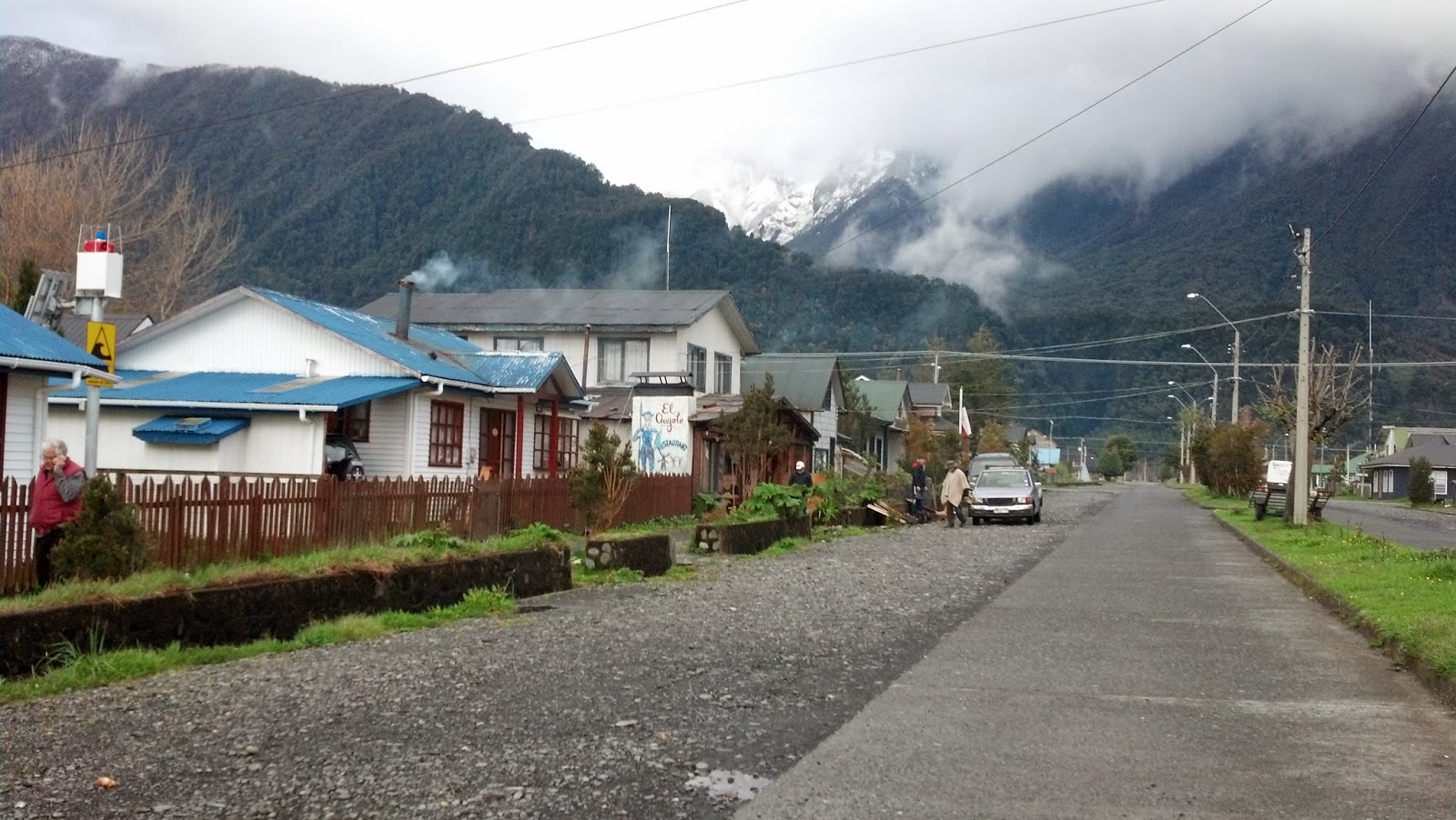 |
| Main street in northern Chaitén |
 Fortunately for us, two of those residents, Carlos and Lidia, have established the Hostal Don Carlos, where we spent a very comfortable first night on our trip down the Carretera Austral. There are other places to stay in Chaitén, and more are popping up as returnees and new entrepreneurs settle into Chaitén, which is now attracting many more visitors than before due to it’s unfortunate notoriety, and the increasingly more passable Carretera Austral. The hospital, totally destroyed, is now being rebuilt and is operating partially; a new ambulance is servicing the community. The Army’s Mounted Exploration Unit returned to inhabit the old Army Regiment facilities near Chaitén after our visit, and a new airstrip will be opened in early 2014.
 |
| Joaco, Dave and Claudio at El Volcán |
wish I could have been there too!
ReplyDeleteI just completed reading about the first leg of your trip and I'm looking forward to the next installment.
ReplyDeleteBruce